 9 hours Ago
VANCOUVER, British Columbia, March 13, 2025 (GLOBE NEWSWIRE) -- Greenridge Exploration Inc. (“ Greenridge ” or the “ Company ”) (CSE: GXP | FRA: HW3 | OTCQB: GXPLF) , is pleased to announce the engagement of Expert Geophysics Surveys Inc. (“ EGS ”) to carry out a helicopter-borne Mobile MagnetoTellurics System (“ MobileMT ”) survey at the Sabre Uranium Project (the “ Sabre Property ”, or the “ Project ”) located in the northern Athabasca Basin region of Saskatchewan, Canada.
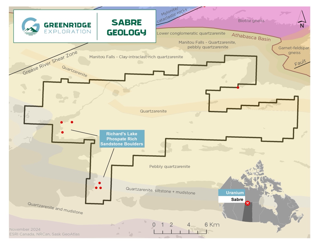
The MobileMT survey is planned to consist of 1,536-line kilometres at 200-metre line spacing over a 232 square kilometre area with the goal of mapping sub-surface magnetic signatures and detecting conductive zones within the margin of the Athabasca Basin that may be prospective for hosting uranium mineralization. Mobilization of fuel is planned during March 2025 to utilize the existing winter service road from Stony Rapids with the MobileMT survey scheduled to begin in the Spring of 2025. Figure 1 – Greenridge Exploration Sabre Uranium Property The Company believes that the use of the MobileMT system is ideal for the advancement of exploration at the Sabre Property, and the Company looks forward to the completion of the airborne survey and the interpretation of its results to develop new drill targets.
The Sabre Property is fully permitted for uranium exploration, including prospecting, geophysical surveys and drilling, until November 30, 2027. Engagement with local communities is ongoing with the goal of creating a mutually beneficial relationship between the Company and the residents of the Northern Athabasca region. Figure 2 - Sabre Property; Proposed Flightlines for 2025 Airborne MobileMT survey About the Sabre Property and the EGS MobileMT Survey The Sabre Property is located on the northern edge of the Athabasca Basin approximately thirty (30) kilometres west of Stony Rapids and ten (10) kilometres south of Fond du Lac, Saskatchewan.
The Project consists of 28 claims totaling 23,178 hectares and is believed to be prospective for hosting unconformity-related uranium mineralization. The Fond du Lac uranium deposit, a shallow, sandstone-hosted deposit with a historic reserve of approximately 990,000 pounds (450,000 kilograms) averaging 0.25% U 3 O 8 is located approximately 5.
5 kilometres to the northwest of the Project’s western boundary, which may demonstrate the prospectivity of the region for the deposition of uranium mineralization. 1 Historical exploration at the Sabre Property has identified anomalous uranium-bearing sandstone boulders and outcrop at surface, numerous interpreted fault structures, and electromagnetic (“ EM ”) conductors interpreted to lie at depths greater than three hundred (300) metres. Graphitic conductors can provide favourable conduits and host environments for the deposition of uranium at or near the unconformity between the Athabasca sandstones and the older Aphebian basement rocks.
Drill testing for uranium within the current boundaries of the Sabre Property is limited to five (5) historical drill holes. Hole MNL-02, drilled in 2006, intersected highly anomalous dravite veining (boron-rich clay mineral) in the sandstone at a depth of 290.5 metres, which is a clay alteration mineral that is commonly associated with uranium mineralization in the Athabasca Basin.
EGS’s MobileMT system was introduced in 2018 for use in the field of Airborne Natural Source Audio Frequency MagnetoTellurics (“ AFMAG ”) and is presented by EGS as the most advanced generation of airborne AFMAG technologies. The energy from global thunderstorm activity is converted into an underground electromagnetic plane wave, which serves as the primary field in the airborne natural field. technology The EM fields and currents induced by these fields in the subsurface are used in MobileMT to identify variations in sub-surface electrical resistivity.
MobileMT has a potential depth of investigation of over one (1.0) kilometre and is an ideal airborne EM method for use in areas of the Athabasca Basin where depths to the unconformity can increase from zero to hundreds of metres over a distance of several kilometres from the edge of the Athabasca Supergroup sandstones. In August 2018, EGS flew a MobileMT test line over the Shea Creek uranium deposits (“ Shea Creek ”) area in the Western Athabasca basin, just south of the former Cluff Lake uranium mine site.
Shea Creek displays a full range of the uranium mineralization and alteration styles found in the Athabasca Basin 4 including: Unconformity-type uranium mineralization along the Saskatoon Lake conductor; Basement uranium mineralization localized mainly in the footwall of the geophysical conductor; An alteration plume developed above mineralization and surrounded by clay-chlorite alteration in sandstone. 3 The result of the 2018 MobileMT test survey line crossing the Kianna unconformity-style uranium mineralized zone (the “ Kianna Zone ”) at Shea Creek is shown in Figure 2. The Kianna Zone, discovered by drilling in July 2005 and reported by the Orano Canada-UEX Corporation joint venture (discovery hole SHE-114-5 intersected 27.
4% U 3 O 8 over 8.8 metres, including 58.32% U 3 O 8 over 3.
5 metres 2 ), is located at the unconformity between the Athabasca sandstone and the underlying basement rocks (shown in Figure 2 as the warm-coloured conductive zone at the approximate 12,000 metre mark along the MobileMT test survey line and lying at greater than 750 metres depth). Figure 3 - MobileMT resistivity section over the Kianna Zone 3 The successful application of MobileMT at the Kianna Zone illustrates the ability of the survey method to detect deep conductors along with distinguishing comparatively weak resistivity variations interpreted as potential alteration haloes in a highly-resistive sandstone environment. References: 1 Saskatchewan Mineral Deposits Index (SMDI) #1572 ; 2 UEX Corporation News Release dated July 13, 2005 ; 3 Minerals 2024 - “ Airborne Natural Total Field Broadband Electromagnetics – Configurations, Capabilities, and Advantages", by Prikhodko , Bagrianski , and Kuzman ; 4 Rhys, D.
A., Eriks , R.S.
, and van der Meer, L., 2010: Geology of the Shea Creek uranium deposits. Saskatchewan Geological Survey, Open House.
In Abstract Volume, page 6, and as a presentation available on the Saskatchewan Geological Survey website. Statement of Qualified Person The scientific and technical information contained in this news release has been reviewed and approved by Sean Hillacre, P. Geo.
, Technical Advisor and a geological consultant to the Company and a Qualified Person as defined in National Instrument 43-101 – Standards of Disclosure for Mineral Projects . Mr. Hillacre has examined information regarding the historical exploration at the Sabre ProProperty, which includes a review of the historical sampling, analytical and procedures underlying the information and opinions contained herein.
Management cautions that historical results collected and reported by operators unrelated to Greenridge have not been verified nor confirmed by its Qualified Person; however, the historical results create a scientific basis for ongoing work in the Sabre Property. Management further cautions that historical results, discoveries and published resource estimates on adjacent or nearby mineral properties, or other properties located within the Athabasca Basin, whether in stated current resource estimates or historical resource estimates, are not necessarily indicative of the results that may be achieved on the Sabre Property. About Greenridge Exploration Inc.
Greenridge Exploration Inc. (CSE: GXP | OTCQB: GXPLF | FRA: HW3) is a mineral exploration company dedicated to creating shareholder value through the acquisition, exploration, and development of critical mineral projects in Canada. The Company owns or has interests in 28 projects and additional claims covering approximately 389,210 hectares with considerable exposure to potential uranium, lithium, nickel, copper and gold discoveries.
The Company is led by an experienced management team and board of directors with significant expertise in capital raising and advancing mining projects. Greenridge has one of the largest uranium property portfolios in Canada consisting of 15 projects and additional prospective claims covering approximately 216,405 hectares. The Company has opportunities to realize value in a further 13 strategic metals projects which include lithium, nickel, gold, and copper exploration properties totalling approximately 172,805 hectares.
Project highlights include: The Black Lake property, located in the NE Athabasca Basin, (40% Greenridge, 50.43% UEC, 8.57% Orano) saw a 2004 discovery hole (BL-18) return 0.
69% U3O8 over 4.4m.1 The Hook-Carter property (20% Greenridge, 80% Denison Mines Corp.
) is strategically located in the SW Margin of the Athabasca Basin, sitting ~13km from NexGen Energy Ltd.’s Arrow deposit and ~20 km from Fission Uranium Corp.’s Triple R deposit.
The Gibbons Creek property hosts high-grade boulders located in 2013, with grades of up to 4.28% U3O82, and the McKenzie Lake project saw a 2023 exploration program return three samples which included 844 ppm U-total (0.101% U3O8), 273 ppm U-total, and 259 ppm U-total3.
The Nut Lake property located in the Thelon Basin includes historical drilling which intersected up to 9ft of 0.69% U3O8 including 4.90% U3O8 over 1ft from 8ft depth4.
In 2024, Greenridge’s prospecting program located a float sample that returned 31.13% U3O8, sourced from the Tundra Showing5. The Firebird Nickel property has seen two drill programs (7 holes totaling 1,339 m), where hole FN20-002 intersected 23.
8 m of 0.36% Ni and 0.09% Cu, including 10.
6 m of 0.55% Ni and 0.14% Cu.
6 The Electra Nickel project 2022 drill program included results of 2,040 ppm Ni over 1m and 1,260 ppm Ni over 3.5m.7 The Company has strategic partnerships which includes properties being operated and advanced by Denison Mines Corp.
and Uranium Energy Corp. The Company’s management team, board of directors, and technical team brings significant expertise in capital raising and advancing mining projects and is poised to attract new investors and raise future capital. References: 1 – Black Lake: UEX Corporation News Release dated October 12, 2004.
2 – Gibbons Creek: Lakeland Resources Inc. News Release dated January 8, 2014. 3 – McKenzie Lake: ALX Resources Corp.
New Release dated November 7, 2023. 4 – Nut Lake: Greenridge Exploration Inc. News Release dated February 19, 2024.
5 – 1978 Assessment Report (number 81075) by Pan Ocean Oil Ltd. 6 – Firebird Nickel: ALX Resources Corp. New Release dated April 15, 2020.
7 – Electra Nickel: ALX Resources Corp. New Release dated July 20, 2022. On Behalf of the Board of Directors of Greenridge Russell Starr Chief Executive Officer, Director Telephone: +1 (778) 897-3388 Email: info@greenridge-exploration.
com Disclaimer for Forward-Looking Information Certain statements in this news release are forward-looking statements, including with respect to future plans, and other matters. Forward-looking statements consist of statements that are not purely historical, including any statements regarding beliefs, plans, expectations or intentions regarding the future. Such information can generally be identified by the use of forwarding-looking wording such as "may", "expect", "estimate", "anticipate", "intend", "believe" and "continue" or the negative thereof or similar variations.
The reader is cautioned that assumptions used in the preparation of any forward-looking information may prove to be incorrect. Events or circumstances may cause actual results to differ materially from those predicted, as a result of numerous known and unknown risks, uncertainties, and other factors, many of which are beyond the control of the Company, including but not limited to, business, economic and capital market conditions, the ability to manage operating expenses, and dependence on key personnel. Forward looking statements in this news release include, but are not limited to, statements respecting: completion of the MobileMT survey; anticipated results or benefits from conducting the MobileMT survey at the Property; the Company’s objectives, goals, or future plans with respect to the Project; further exploration work on the Project in the future.
Such statements and information are based on numerous assumptions regarding present and future business strategies and the environment in which the Company will operate in the future, anticipated costs, and the ability to achieve goals. Factors that could cause the actual results to differ materially from those in forward-looking statements include, the continued availability of capital and financing, litigation, failure of counterparties to perform their contractual obligations, loss of key employees and consultants, and general economic, market or business conditions. Forward-looking statements contained in this news release are expressly qualified by this cautionary statement.
The reader is cautioned not to place undue reliance on any forward-looking information. The Canadian Securities Exchange (CSE) does not accept responsibility for the adequacy or accuracy of this release. Photos accompanying this announcement are available at: https://www.
globenewswire.com/NewsRoom/AttachmentNg/8b11a5c3-ed24-47c5-8487-f7b04a88b86c https://www.globenewswire.
com/NewsRoom/AttachmentNg/722bc820-ab8c-4719-8110-9c2f34b63b51 https://www.globenewswire.com/NewsRoom/AttachmentNg/a09a84d6-dc08-4e23-8338-f180e6188d51.